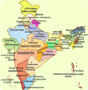
India brings you face to face with startling diversity - from different terrains and languages to a wealth of regional cultures. India needs a lifetime to be explored, from its rustic villages to its modern cities, from the mighty Himalayas to the sunny beaches, from its ancient temples and palaces to the exquisite handicrafts and artistic produce.
Andhra Pradesh
Andhra Pradesh, known as the "Rice Granary of India" is the favourable tourist state in India, which has a coastline of 1000 kms with eight of its 23 districts having direct access to the sea. Located in South India, Andhra Pradesh is bounded by Tamil Nadu in the south, Maharashtra in the North and North-West, Madhya Pradesh in the North-East, Karnataka in the West, and by the Bay of Bengal in the East. The medieval city of Hyderabad is its capital. The main languages that are spoken in Andhra are Telugu, English, Urdu, Hindi.
General Information
Area: 275,068 Sq Km
Capital: Hyderabad
Language: Telugu and Urdu
Districts: 23
Population: 66,508,854
For further information log on to
http://www.aptourism.in/
Arunachal Pradesh
Arunachal Pradesh is bordered by China in the north, Bhutan in the west, Myanmar (Burma) in the east and shares its boundaries to the south with Assam and Nagaland.
Area : 83,743 Sq Km
Population : 1,091,117(Provisional 2001census)
Capital : Itanagar(Population-34970 (Provisional 2001 census)
Clothing : Summer-cotton,
Winter- heavy woolen
Wildlife Sanctuaries : Itanagar, Pakhui, Laki Mehao
National Parks : Namdapha, Mouling
For further information log on to http://www.arunachaltourism.com/ ,
http://arunachalpradesh.nic.in
Assam
Assam is a state of breath taking scenic beauty, rarest flora and fauna, lofty green hills, vast rolling plain, mighty waterways and a land of fairs and festivals.The ancient name of Assam was Pragjyotishpur. However, during the time of the Ahom conquest, Pragjyotishpur was known as Kamrup. In ancient Sanskrit literature, both the names Pragjyotishpur and Kamrup were used as a designation for ancient Assam. In 1228, the Ahoms, Shan tribe from North Thailand entered and defeated the Kamrup ruler and established a kingdom, which came to be known as Assam with its capital at Sivasagar (Sibsagar). Most probably, the modern name Assam comes from Ahoms, the dynasty that ruled from the 13th to early 19th Century. The ancient name Kamrup, is today confined to only a district of Assam.
For further information log on to http://assamgovt.nic.in/
Bihar
Bihar, an eastern Indian state and the place that gave birth to Buddhism and Jainism and helped in the growth of Sikhism and Hinduism, has a past that is unmatched anywhere in the world. It was the center of first republic in the world at Vaishali. The city of Patliputra was largest and grandest in the world at the height of its glory. Even today, the state is amongst the largest mineral producing regions in India and contributes immensely in national wealth creation. There is an array of tourist destinations of diverse interests in the state, though their potential has not been exploited fully till now. The state that represents every thing good and bad within the country is waiting to be explored and rediscovered
GENERAL INFORMATION
Capital : Patna
Area : 173,877 sq km
Religion : Hinduism (82.42%), Islam (14.80%), Others (2.78%)
Temperature : Max 30 degrees C Min 5 degrees C
Languages : Hindi, Maithili, Bhojpuri
Altitude: 173 Ft.
For further information log on to http://bihar.nic.in/
http://www.nic.in/ptdc/
Chhattisgarh
Chhattisgarh, a 21st century State, came into being on November 1, 2000. Larger than Tamil Nadu, it is just the right size, and is also fortunate to have a low population density. Good Governance is the highest priority in this Fast Track State. There is both policy stability as well as political stability. Government has been kept small and the State is in excellent fiscal health.
GENERAL INFORMATION
Area: 65 Sq. Km.
Altitude: 298 Mt.
Temperature:
Summer Max: 42.0°C Min: 26.0°C
Winter Max: 26.0°C Min: 12.0°C
For further information log on to www.chhattisgarhtourism.net
Goa
Goa, on the west coast of India is a land of swaying palms, miles of golden sands, lush greenery, an incredible cultural heritage, magnificent churches, temples and monuments and a unique cultural synthesis of the east and west.
General & Essential Information
Area : 3,702 Sq. KM
Altitude : Sea level to 1022 Mts.
Temperature : Summer Max: 33 Deg. C. Min: 26 Deg. C.
Winter Max: 31 Deg. C. Min: 20 Deg.C.
Rainfall : 350 Cms. (June to September).
STD Code : 0832 (95-832 from Mumbai).
Languages : Konkani, Marathi, English & Hindi
For further information log on to http://www.goacom.com/
http://goagovt.nic.in
Gujarat
Situated on the western part of the Indian sub-continent, Gujarat derives its name 'Gujaratta' meaning the land of Gurjars. The Gurjars passed through Punjab and settled in some parts of Western India, which came to be known as Gujarat.
Gujarat today offers a wide range of the most spectacular attractions - which includes breathtaking locations and scenic landscapes. Gujarat is also a melting pot of several civilizations resulting in a vibrant culture and a rich heritage. Gujarat is home to several architectural marvels, witnesses of its glorious history and pilgrim centres for many faiths. Finally, it is also the land of several mythological & historical figures like the legendary Krishna and Mahatma Gandhi the apostle of non-violence.
For further information log on to http://www.gujarattourism.com/
Haryana
As the cradle of the ancient Vedic Civilization, the 5000-year-old history of Haryana is full of glory. It was here in Haryana, that Lord Krishna taught us about Karma and Dharma through "The Bhagwad Gita". It was here that Ved Vyas wrote Mahabharat (in Sanskrit) on the banks of Saraswati River. Recent archeological excavations in sites like Kunal and Banawali, are adding much more to our knowledge of Haryana's history. Arya Samaj has a large number of followers among Haryana's people. Haryana has a rich variety of craft, folk dances and fairs & festivals. Haryana became a new state of India on 1st November 1966, with Chandigarh city as its capital.
Haryana has set up many tourist complexes, motels and camping sites in landscaped gardens to promote tourism. Haryana has one of the most successful tourist development programs led by Haryana Tourism department. The tourist complexes are named after Birds found in Haryana.
For further information log on to http://www.haryanatourism.com/
Himachal Pradesh
Himachal Pradesh is a "mountain state" and a delight for visitors, particularly during the summer season when people flock to this tiny hill station to escape the scorching heat of the plains. It came into being in its present form with the partition of the Punjab into Punjab and Haryana in 1966. The winding roads and high passes link its high mountains and valleys are the high points of a visit to this state. While the picturesque valleys of Kullu and Kangra are a blend of colours, in marked contrast the stark and barren terrain of Lahaul and Spiti have a stunning moonscape like beauty.
The State is bordered by Jammu & Kashmir on North, Punjab on West and South-West, Haryana on South, Uttar Pradesh on South-East and China on the East.
For further information log on to http://www.hptdc.nic.in/
Jammu and Kashmir
Location - Strategically located, the State of Jammu and Kashmir constitutes the northern most extremity of India. Situated between 32.17 degree and 36.58 degree north latitude and 37.26 degree and 80.30 degree east longitude, the total area of the State is 2,222,236 sq. kms including 78,114 sq kms under the illegal occupation of Pakistan and 42,685 sq kms under that of China, of which Pakistan illegally handed over 5,130 sq kms to China. The State is bounded by Pakistan, Afghanistan and China from the West to the East.
Capital :
Summer (May-October)-Srinagar
Winters (Novemenber-April)Jammu
Languages :Urdu, Kashmiri, Hindi, Dogri, Pahari, Ladakhi,
Area :2,22,236 Sq Kms.
For further information log on to http://www.jktourism.org/
Jharkhand
The hype, the glitter, the urban settings and even five star hospitality are conspicuous by its absence in this state. Not with standing all these, the ripple of the falls as they cascade down steep mountain slopes seem as mighty as Lord Shiva's Tandav. History stands still amidst the serenity of hundreds of years old rich teak forests of Saranda that have witnessed the rise and fall of the British Empire.
Jharkhand, formerly a part of United Bihar became the 28th State of India on 15th November 2000. The capital of Jharkhand is Ranchi.
For further information log on to http://www.jharkhand.nic.in/tourism/tour.htm
Karnataka
Situated in the southern part of India, the state of Karnataka spreads over the Deccan Plateau. At 300B.C., it had formed the southern tip of the Mauryan Empire. Its boundaries enlarged or receded swaying to the drum beats of history & today it accounts for a sixteenth area of India & has a population of about 45 million. Its language is Kannada & its people are known as kannadigas. The three distinct regions are a narrow coastal area along Arabian Sea; high hills, the Western Ghats; & sprawling plains towards the east.
Karnataka popularly known for Carnatic Music through out the World has given much more to the World than Carnatic Music, a unique form of Classical Music patronized by many across the continents. Karnataka with all its richness in culture and traditional grandeur is also one of the fastest growing states in terms of industries and facilities. Karnataka is also known as the Capital of Agarbathi (Incense Sticks), Arecanut, Silk, Coffee and Sandal Wood.
For further information log on to http://kstdc.nic.in/
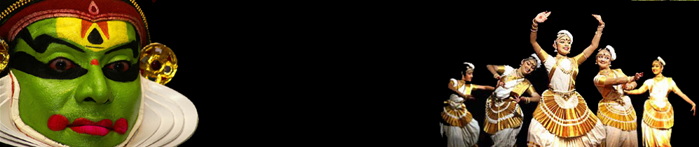
Kerala
Welcome to Kerala, God's Own Country. With the Arabian Sea on the west, the western ghats towering 500 - 2700m on the east and Kerala is networked by forty-four rivers. Kerala is a very easy place to simply sit back and enjoy. The name means "land of coconuts" and the palms shade nearly the entire state from the tropical sun; many call the beach at Kovalam the best in India, tranquil stretches of emerald backwaters, lush green hill stations and exotic wildlife, ayurvedic health resorts, enchanting art forms, magical festivals, historic and cultural monuments, an exotic cuisine
all of which offers a unique experience.
Kerala is one of the ten 'Paradises Found' declared by the National Geographic Traveler, for its diverse geography and overwhelming greenery. It is a land much acclaimed for the contemporary nature of its cultural ethos, and much appreciated for the soothing, rejuvenating paradise that it is.
GENERAL INFORMATION
Area: 38,863 sq km, which is 1.27% of India's total land area and is located at the Southwest tip of the India's main land
Weather: Tropical
Summer: April-June [24 - 33 degree Celsius]
Monsoon: July-September [22 - 27 degree Celsius
Winter: October-March [22 - 32 degree Celsius]
High Season: December-May
Capital: Thiruvananthapuram (Trivandrum)
Language: Malayalam; however English is widely spoken and understood by the fully literate populace of Kerala.
Number of Districts: 14
Major Cities: Thiruvananthapuram, Kochi (Ernakulam district) & Kozhikode (Calicut)
For further information log on to http://www.keralatourism.org
GMadhya Pradesh
Madhya Pradesh is called the "heart of India" not only because of its location in the centre of the country, but has been home to the cultural heritage of Hindhuism, Buddhism, Jainism and Islam. Innumerable monuments, exquisitely carved temples, stupas, forts and palaces are dotted all over the State. The natural beauty of Madhya Pradesh is equally varied. Consisting largely of a plateau, the State has everything. Spectacular mountain ranges, meandering rivers and miles and miles of dense forests offering a unique and exciting panorama of wildlife in sylvan surroundings.
For further information log on to http://www.mptourism.com/
Maharashtra is
Located in the northern center of peninsular India, Maharashtra is surrounded by the Arabian sea in the west, Gujarat and Madhya Pradesh on the north, Madhya Pradesh in the east and Karnataka and Andhra Pradesh on the south. Mumbai is the capital of Maharashtra, which derives its name from the Goddess Mumba Devi.
Mughal rulers from Delhi tried their best to keep this region under their control. From the middle of the 17th century, a new group of warrior people came to dominate the scene in Maharashtra and elsewhere in India called Marathas. The origin of Marathas is still debatable, but what is known is that they stole the limelight from the great Mughals and at one point of time even captured Delhi. It was only after defeating the Marathas that the English could establish their rule in India. Shivaji was the first great ruler of Marathas and it was he who paved the way for future Maratha influence on India.
For further information log on to http://www.maharashtra.gov.in
Manipur
MANIPUR shares 352 km common International boundary with Myanmar and lies south of Nagaland, north of Mizoram and east of Assam. It covers an area of 22,327 sq. km with a population of 23,88,634(Provisional census 2001). Manipur is a mosaic of traditions and cultural patterns.
For further information log on to http://manipur.nic.in/
Meghalaya
Location: Meghalaya lies between 25o and 26.15o North Latitude and 89.45o and 92.47o East Longitude. It is bounded on the North and East by the State of Assam and on the South and West by Bangladesh.
Meghalaya is inhabited by three tribal groups namely the Khasis, the Jaintias and the Garos. The Khasis reside in the centre of the State, the Jaintias in the east and Garos in the west. Khasis, Jaintias, Bhois, Wars collectively known as the Hynniewtrep people are of Austro Monkhmer race and Garos who prefer to call themselves as Achiks are of the Tibeto-Burman race. All the three tribes follow the matrilineal system of society where the lineage and ancestral property pass down from mother to daughter. According to scholars, the Hynniewtrep(seven huts)people are known to be the earliest settlers in the undivided state of Assam and one of the earliest ethnic group of settlers in the Indian sub-continent.
For further information log on to http://www.meghalayatourism.com
Mizoram
MIZORAM is located in the northeastern part of India. It is bound by Assam and Manipur in the north, Myanmar in the east and south and Tripura and Bangladesh in the west. The Tropic of Cancer passes through the middle of Mizoram and therefore the climate of this area is neither very cold in winter nor very hot in summer.
The average winter temperature ranges between 11 and 21 degree Celsius.
The summer temperature ranges between 20 and 30 degree Celsius.
GThe State has thick bamboo forests and boasts of a number of streams and rivers. Wild animals found in the State are barking deer, blyths, tragopan, stump tailed macaque, swamp deer, tiger, leopard, elephants, hoolock gibbon, sambar, wild boar, wild cats, hornbill, pheasant etc.
For further information log on to ttp://mizotourism.nic.in/
Nagaland
Nagaland is bound by Arunachal Pradesh and parts of Assam in the North; Manipur in the South; Myanmar (Burma) on the East and Assam in the West. 16 major tribes along with other sub-tribes inhabit the State. Each of the sixteen odd tribes and sub-tribes have their own languages, customs and traditions and they can easily be distinguished by their colourful dresses, ornaments and beads that they wear. The traditional ceremonial attire of each tribe is very colourful and attractive.
Nagaland is blessed with a salubrious climate throughout the year. The temperature from June to September is between 16 to 31 deg Celsius and from October to February it is between 4 & 24 degree Celsius.
The main rivers of the state are the Dhansiri, Doyang, Dikhu, Milak, Zungki and Tizu and the highest peak is Saramati, which are approximately 3841 metres above sea level. The land, flora, fauna, the people and their warm hospitality all combine to make Nagaland and ideal destinations for the tourists.
Location : Between 25 degree 6' and 27 degree 4' latitude, North of Equator and between the Longitudinal lines 93 degrees 20'E and 95 degree 15' E.
For further information log on to http://www.nagalandtourism.com/
Orissa
Orissa is an attractive treasure house of cultures and customs, religions and traditions, languages and literature, art and architecture, scenic beauties and wildlife. Situated on the eastern coast along the Bay of Bengal, Orissa stands for its ancient glory and modern endeavour. The state once formed a part of Kalinga kingdom which is best known in ancient history for its brave resistance against the invasion of the Mauryan King Ashoka in the 3rd century B.C., who ultimately conquered it . That the emperor turned to Buddhism and peace after witnessing the bloodshed in this war is well known. This also formed the turning point in the history of Orissa giving a boost to art and architecture in the ancient kingdom. The state rose to prominence as a kingdom under Kharavela, a great conqueror and patron of Jainism, in the second half of the 1st century B.C. Other great rulers were the kings of the Kesari dynasty and the Eastern Ganga dynasty who were also great builders.
Borders: West Bengal in north-east, Bihar in the north, Madhya Pradesh in the west, Andhra Pradesh in the south and the Bay of Bengal in the east.
For further information log on to http://www.orissa-tourism.com/
Punjab
General Information
Area: 50362 square kilometers (1.54 % of the country's total geographical area.)
Location: Punjab is situated in the northwest of India; it is bordered by Pakistan on the west, the Indian states of Jammu and Kashmir on the north, Himachal Pradesh on its northeast and Haryana and Rajasthan to its south.
Geographical Co-ordinates
Latitude: 29'30'' N to 32'32'' N
Longitude: 73'55" E to 76'50" E
Population: 24.29 million
Density: 482 per sq. km.
Literacy: 69.95%
Capital: Chandigarh
Languages: Punjabi and Hindi.Many people are fluent in English and Urdu
For further information log on to www.punjabtorurism.org
Rajasthan
Located on the northwest borders of India, Rajasthan stretches out in to the Thar Desert. Rajasthan, literally translated as the land of kings & princes, is the ultimate confluence of history, chivalry, romance, rugged natural beauty, art & crafts and colour.
Against the backdrop of the dull desert landscape & the once impregnable sand coloured forts. It is the land of colourful people and attire, who narrate amazing legends of heroism and romance. Legends, which still resound from its equally amazing architecture standing erect, a witness to a glorious bygone era.
For further information log on to http://www.rajasthantourism.gov.in
Sikkim
Sikkim has the unique distinction of being bounded by three sovereign nations, Nepal in the west, Bhutan in the east and China's Tibet in the north. It also shares its southern border with the state of West Bengal. It has an area of around 7096 sq km and it is about 64 km from east to west and 110 km from north to south. Mt. Kanchendzonga, the third highest peak in the world dominates the landscape of the State and is revered as Sikkim's guardian deity. The state has a good number of glaciers and some of the very important ones are Zemu, Rathong, Lona in North Sikkim. The river Tista is the lifeline of Sikkim and it originates from Lake Cholamu. Its tributaries are Rangeet, Ramam and Rangpo. Sikkim offers best buys for hand woven carpets, thankas and other paintings. Other items typical of the state and are large cardamoms, Lepcha weave bags, purses, jewellery and liquors etc. The main inhabitants of the state are the Lepchas, Bhutias and Nepalis.
For further information log on to http://www.sikkimtourism.travel
Tamil Nadu
Karnataka and Andhra Pradesh bound Tamil Nadu in the north and Kerala in the west. The waters of the Bay of Bengal and the Indian Ocean lap the coastal eastern and southern boundaries respectively. The Point Calimere and Mudumalai wildlife sanctuaries define the eastern and western tips of the state while on the northern extreme is Pulicat Lake and the southernmost tip is Cape Camorin or Kanniyakumari - the Land's End of India.
Traditionally, the land of Tamils has been divided into 5 major physiographic divisions - the Kurinji or mountainous region, the Mullai or forest region, the Palai or arid region, the Marudham or the fertile plains and the Neidhal or coastal region.
For further information log on to http://www.tidco.com
Tripura
GENERAL INFORMATION :
Area : 10,492 sq km
Capital : Agartala
Altitude : 12.80 metres
Population : 3191168 (Provisional census-2001)
Temperature : Summer: 20 to 36 degree C. Winter: 7 to 27 Degree C.
Clothing : Summer-Cotton. Winter- Woollens
Rainy Season : June to August
Average rainfall : 2100 mm per annum
Official Languages : Bengali and Kok Borok
Other Languages : Manipuri, English, Hindi, Chakma etc.
Winter 2 deg. C Min
For further information log on to http://tripura.nic.in
Uttar Pradesh
Uttar Pradesh is the rainbow land where the multi-hued Indian Culture has blossomed from times immemorial. Blessed with a variety of geographical topographies and many cultural diversities, Uttar Pradesh, has been the hub of activity of historical and religious heroes like - Rama, Krishna, Buddha, Mahavira, Ashoka, Harsha, Akbar and Mahatma Gandhi. Rich and tranquil expanses of meadows, perennial rivers, dense forests and fertile soil of Uttar Pradesh have contributed numerous golden chapters to the annals of Indian History. Dotted with various holy shrines and pilgrimage places, full of joyous festivals, it plays an important role in the politics, education, culture, industry, agriculture and tourism of India.
For further information log on to http://www.up-tourism.com/
Uttaranchal
Uttaranchal is a small newly formed state of India, and is the true experience to the first meeting with the Himalayas. Blessed with magnificent glaciers, majestic snow-clad mountains, gigantic and majestic peaks, valley of flowers, skiing slopes and dense forests travel to Uttaranchal is a dream come true. A pious destination for the religious with the four most sacred and revered Hindu sites Badrinath, Kedarnath, Gangotri and Yamunotri (collectively known as the Char Dham Yatra ) nestled in the mighty mountains; a challenging destination for the adventure seekers with sports that are offered like River Rafting, mountaineering, skiing and trekking; and a picturesque destination for the nature lovers with breathtaking panoramic view of Himalayas, and the lovely valley of flowers. Most of the famous hill stations other than the Capital of the state Dehradun, like Mussorie and Nainital are situated in Uttaranchal. The Corbett National Park and the Rajaji wildlife park famous for its Tigers and wildlife is another reason to visit the state. No part of the state lacks in the natural splendour that Mother Nature has bestowed on the state and travel to Uttaranchal certainly leaves behind the most beautiful memories.
For further information log on to www.ua.nic.in/uttaranchaltourism
West Bengal
West Bengal was created as a constituent state of the Indian union on 15th August 1947 as the result of partition of the undivided British Indian province of Bengal into West Bengal. West Bengal covers the bottleneck of India in the east, stretching from Himalayas in the north to the Bay of Bengal in the south. It is bounded on the north by Sikkim and Bhutan, on the east by Assam and Bangladesh. On the south by the Bay of Bengal and on the west by Orissa, Bihar and Nepal. It has therefore, three international frontiers-to the north, east and west. The state lies between 27o13'15" and 21o25'24" north latitudes and 85o48'20" and 89o53'04" east longitudes.
For further information log on to http://www.wbtourism.com/
Union Territories
Andaman & Nicobar
An Archipelago of 572 islands adrift in the Bay of Bengal, the union territory of Andaman & Nicobar Islands stretches over an area of more than 700 sq. kms. Port Blair and its surroundings offer sightseeing possibilities that interest all. There is history, nature and beauty that will fascinate you.
If you love the sight of wispy coconut palms swaying in the breeze
the feel of soft white sand under your bare feet
the flash of birds vivid against the blue sky
the games of the green shadows in the forest
the infinite variety of under water marine life
you enjoy it all when you are in Andamans & Nicobar Islands, also known as Emerald Islands for the breath taking colour of the sea.
Pondicherry
The inherent ambience of Pondy, as Pondicherry is fondly called, becomes most evident in the oldest part of the town, which flanks the seashore boulevard. Colonial buildings, some which trace back to the 18th century, line along a grid of straight clean streets and house the French institutions, private homes and businesses, and the sprawling premises of the famous Sri Aurobindo Ashram. Mellow colours of cream, yellow, pink and grey greet the visitor with flamboyant bougainvillea bursting over gates and compound walls of cool courtyards.
For further information log on to http://www.tourisminpondicherry.com
Dadra and Nagar Haveli
The Union Territory of Dadra and Nagar Haveli is wedged between the highly industrialised cities of Mumbai, Surat and Vapi. From 1779 to 1954, the land was administered by the Portuguese colonialists and later, after its liberation, by a local administration until 1961 when it merged with the Indian Union. Silvassa is the capital of the Union Territory.
Silvassa - Capital
'Silva' in Portuguese means 'woods' and this can be seen when you visit Silvassa, the tiny, sleepy capital township, with tall trees lining the roads, lush green forests.
For further information log on to http://www.silvassatourism.com
SDaman & Diu
The districts of Daman & Diu became a Union Territory after de-linking from Goa which attained statehood on May 30, 1987. Daman is separated from Gujarat by the Kolak river in the north and the Kalai river in the south. On its west is the Arabian sea. The main river Daman Ganga divides the town into two parts Moti Daman in the south and Nani Daman in the north.
For further information log on to http://www.damantourism.com/
Lakshwadeep
Scattered around 200 km - 400 km west off the Kerala coast, lie the islands of the Union Territory of Lakshadweep, an archipelago of 27 coral islands and open reefs. Out of these islands, only ten are inhabited and they are Andrott, Amini, Agatti, Bitra, Chetlat, Kadmath, Kalpeni, Kavaratti, Kiltan and Minicoy. These islands form the smallest of the Union Territories of India, and are the country's only coral islands. The main islands are Kavaratti, Minicoy, and Amini. Kavaratti is the headquarters of these islands, while Bitra is the smallest of all, with a nominal population. About 93 percent of the people in Lakshadweep are the Shafi school Muslims of the Sunni sect, and they speak Malayalam.
For further information log on to http://lakshadweep.nic.in/lakislscvr.htm